To the county boundary with Pigling Bland
The first, and for a long time the only, Beatrix Potter book I owned was The Tale of Pigling Bland. I chose it from a shop somewhere in the Lake District while on holiday as a child. I can’t recall why I selected this particular tale, but I’m glad I did. There is a melancholy air to the story. Pigling is separated from his family and sent to market. His ambitions are modest; all he really wants to do is grow potatoes. But he is obedient and heads off dutifully, if reluctantly. Events, as they always do in a story, intervene. His romance with the Berkshire Pig-wig is shy and sweet. She is equally resigned to her fate (‘bacon, hams’), though Pigling is horrified.
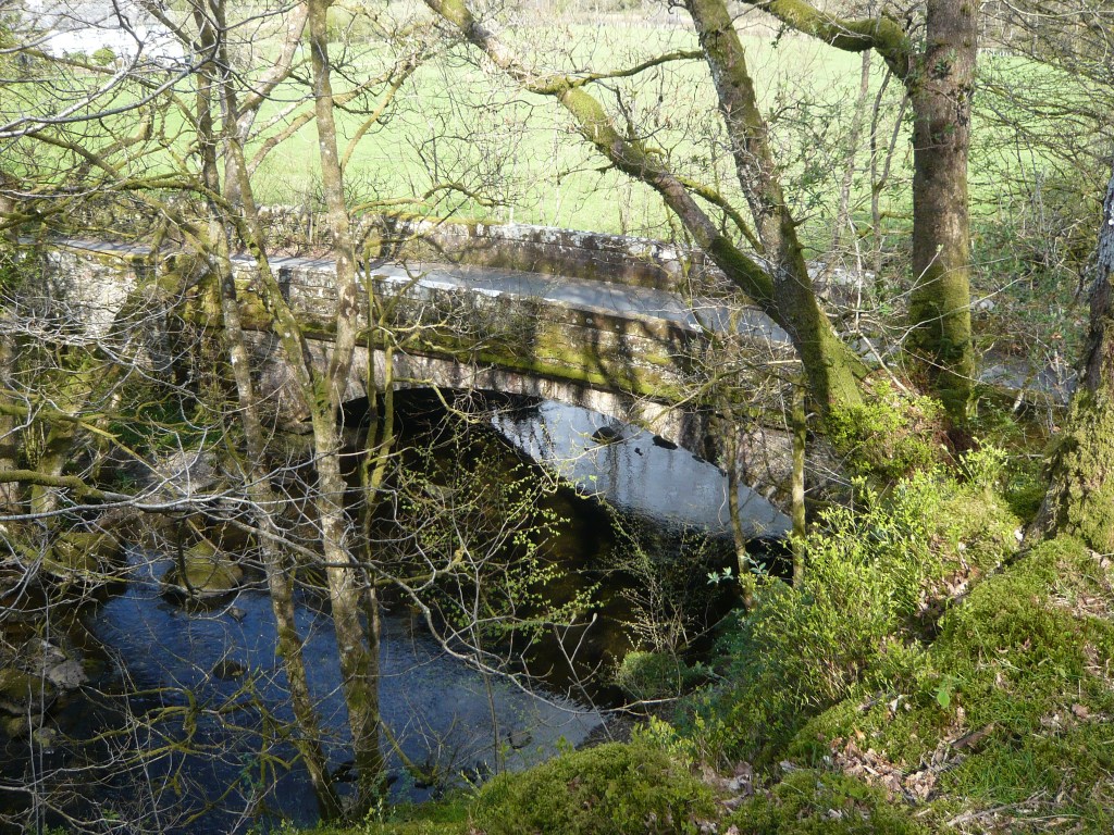
Early on, the author informs Pigling and his feckless brother Alexander that once they cross the county boundary they can never come back. I’ve never understood why this should be the case, but it adds weight to Pigling’s decisions – there is something awesome about taking a decision that is irreversible. As a result, Westmorland on the other side of the border, takes on a faintly mystical air – the promised land, but from where you can’t go home again. And as befits the crossing of a significant boundary, it is marked by a bridge. The internet reliably informs me the bridge in question is Colwith Bridge. The River Brathay, which it crosses, marks part of the boundary between historical Lancashire and Westmorland.
“They came to the river, they came to the bridge – they crossed it hand in hand – then over the hills and far away she danced with Pigling Bland!”
The Tale of Pigling Bland, Beatrix Potter
Ramble #5
Map and route: OS Explorer Map OL7. I’ve plotted the route I took here.
Distance: 9 miles
Start: Tarn Hows car park, SD 326 995 (This area was a favourite with Potter. She purchased the estate when it came up for sale, later selling parts and bequeathing the rest to the National Trust.)
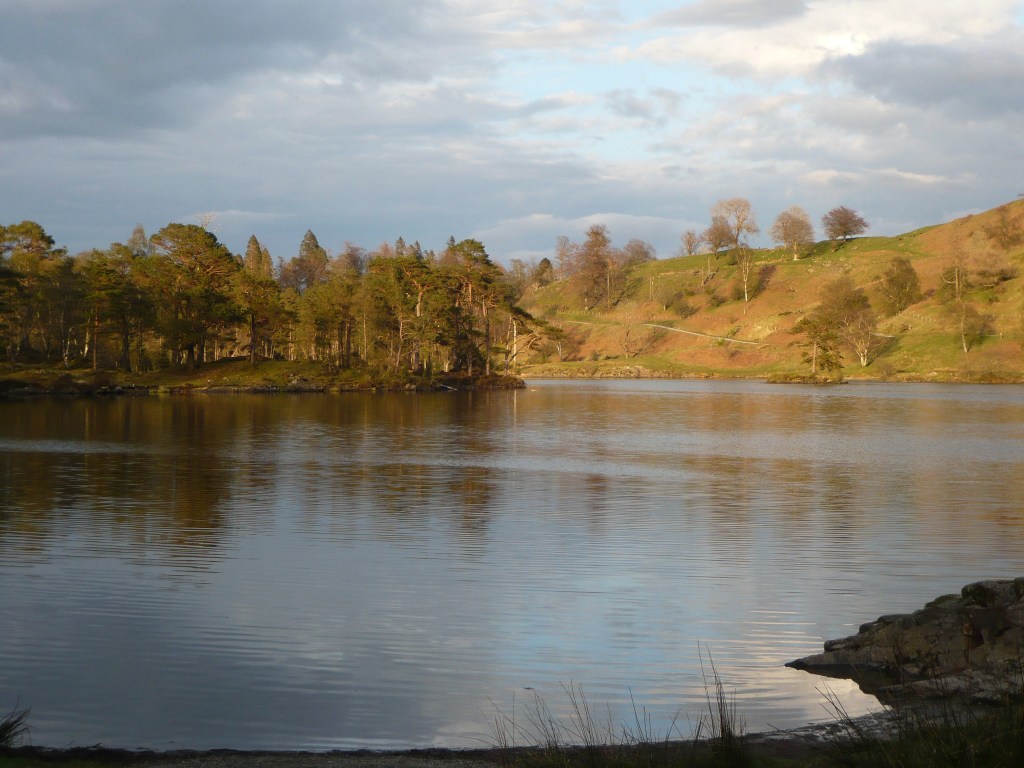
Description: From the car park head over to the tarn and follow the path around to the right. Keep straight on at a finger post and leave the tarn circuit at a stile on the right. Follow the undulating path, climb a stile and cross the track to continue on the path ahead towards Iron Keld. Views open up over to the right. Where the path splits, branch left towards High Arnside. The path climbs steeply then drops down to a track. Turn right through a kissing gate and then turn right almost immediately to follow the path up and over grassy crags to reach the trig point at the summit of Black Crag. Nearby are a couple of beautifully constructed stone cairns. We wandered over to have a closer look. From here there are great views taking in three different lakes (Coniston Water, Esthwaite Water and Windermere) plus at least two smaller tarns.
Head downhill away from the trig with the wall on your right (don’t go over the ladder stile). Head towards the white farmhouse below. When you reach a wall, look for a gate and go through. Continue downhill to reach a distinct stone path, turn right and follow the path past the white house and through the gateway.

Keep left at the fork in the path then right along a way-marked bridle path. Go through a gate and cross a stream using stepping stones by a lovely enclosure. Go through another gate and continue down to the road.
Turn left along the road and then right down a driveway by the layby. Then turn left at the end onto the footpath that crosses the drive. Go through a gate and down steep steps to the river. Emerge from the path onto the road. Turn right along the road to arrive at Colwith Bridge (see the image at the top of the blog). The bridge is gently hump-backed, covered with moss and lichens.
Do not cross the bridge (although if you do, there should be no difficulty returning!) but climb stone steps on your left. Turn right to take the footpath marked to Colwith Force. Follow this lovely woodland path to take a look at bottom of the falls. The river falls approximately 12 meters here over a series of cascades. Retrace your steps a little to climb stone steps to view the falls from above, and what appears to be the remnants of a mill race.
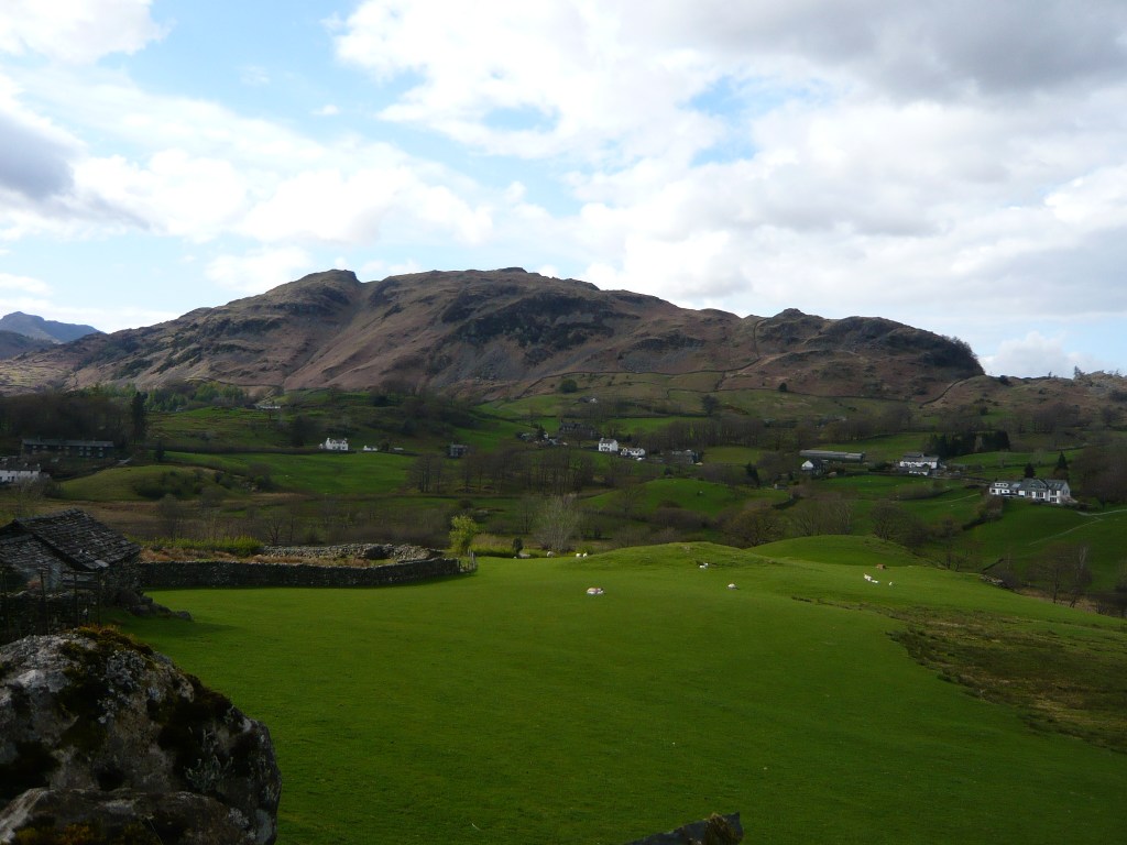
Continue alongside the river for a short way; the path then climbs up and away. When you reach the wall, turn right and go through the gate. Follow the track to a small cluster of cottages at High Park. Turn left as directed then right along the lane. When you reach farm buildings at Stang End, turn left signposted Hodge Close. This lane takes you through what I think of as typical Beatrix Potter country: stone walls, scattered farmsteads, white-washed cottages, hedgerows and green fields and beyond, the fells of Little Langdale. As the undulating path rises, slate workings come into view.
At the junction, turn right through a gate. Branch left at Hodge Close and follow the track as it curls left uphill. Then turn off right through a gate signposted for Holme Ground and Yewdale. Follow this path through woodland, and after passing through a gate look out for a row of houses over to your right. As you pass the houses but before reaching a second gate, turn sharp left on a path uphill onto Holme Fell.
Crest the top of the slope, follow the path down and then contour around to your left, then climb again. When the path branches, take the right up some stone steps and continue onto the summit. The paths through Holme Fell are myriad and not always distinct. The top of Holme Fell is also not particularly obvious and there are cairns marking the surrounding crags. Frankly, this makes it difficult to describe the route. A GPS or similar will help you determine when you have reached the top. The summit is flatish, with a cairn in the middle and a rocky outcrop at the far southern end.
Find you way down from the summit back in the direction you came from, then head eastwards to pick up a clear path that runs steeply downhill at Uskdale Gap. At the bottom, go through a gate into rough pasture where there were belted cattle grazing. Go through a kissing gate onto a farm track. Turn left at a T-junction of paths and follow the track down to the road at Yew Tree Farm. Turn left along the road to the car park at Glen Mary Bridge. Cross the beck and follow the steep path as it climbs through the trees alongside the stream and past the waterfalls to reach the edge of Tarn Hows and the car park. I have to admit, this is rather a steep path to finish on.
Verdict: On reflection, walking this route in reverse might have been better – with the steep stuff early on and then finishing alongside the tarn. Still, in a relatively short walk it packs in a great deal of Lake district variety – fells, waterfalls, woodland and still water.

Leave a comment