A coastal walk through the landscape that inspired Rebecca
I have always been intrigued by the notion that the two wildly different Mrs de Winters in Rebecca are just two sides of author Daphne du Maurier’s own personality. Though the two women approach life very differently, their fates are ultimately similar. And I find myself identifying with both of them at times. Aren’t we all, to some extent at least, made up of apparently conflicting dispositions – sometimes self-assured and outgoing, sometimes doubtful and introverted?
In her biography of Du Maurier, Margaret Forster describes Daphne working on Rebecca while living in Egypt. She struggled to progress much beyond the title Rebecca and a notion for a story about the influence of a first wife on the second. Instead, she fantasized about Cornwall and walking through the woods near Menabilly (the inspiration for Manderley) and hearing the sea. This day-dreaminess makes its way into the resulting novel, most notably with the famous opening in which the unnamed heroine imagines following the now overgrown drive up to the house.
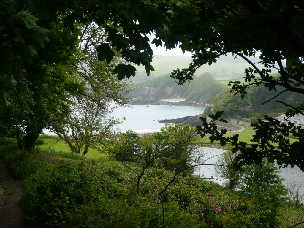
For the past few years I have slowly been working my way along the South West Coast Path. This year I completed the south Cornwall section, including Fowey where du Maurier lived for many years. I was excited to discover that the SWCP passes the little cove (Polridmouth) that is the setting for much of the pivotal action of Rebecca, including the site of Rebecca’s boathouse. As in the book, steep and wooded hills run down to rocky coves and the sea. Further inland and hidden in the trees is Menabilly.
And you came out of the valley, heady and rather dazed, to the hard white shingle of the beach and the still water. A curious, perhaps too sudden contrast…
Rebecca, Daphne du Maurier
Ramble #6
Map and route: OS Explorer Map 107. I’ve plotted the route I took here.
Distance: 6.3 miles
Start: Polkerris Harbour, SX 093 520. As I completed this route as part of walking the coast path, I actually walked from nearby Par. There is a pay and display car park in Polkerris and buses running between Newquay and Fowey stop by the turn-off from the A3082. As well as public toilets in Polkerris, there is a pub, beach shop and a cabin selling drinks and snacks, where I got a delicious bacon cob – just the thing on the damp and drizzly morning I completed this walk.
Description: From the harbour front, with the beach on your right, walk uphill to pick up the signposted coast path, taking the stone steps on your right. The path zigzags lazily through woodland, which was pungent with the smell of ramsons (wild garlic) when I walked this route in May.
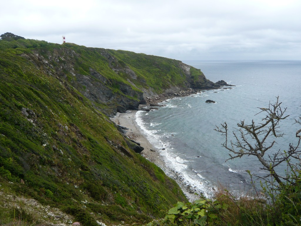
As you emerge from the trees, turn right along the footpath, following way-markings with the acorn symbol denoting a National Trail. Pass through a gate and walk along the cliff tops with great views back along the coast to the headlands of Black Head, Chapel Point and Dodman Point in the distance. Having walked there just two days previous, I liked to think I could still see the tiny blip of the stone cross on Dodman.
Follow the coast path as it undulates along the cliff, flanked by meadows. Climb up steep steps and pass between hedges. As you crest the top of a slope the candy-striped daymark of Gribben Tower suddenly comes into view. Pass a National Trust sign for Gribben Head and keep right where a track branches off to the left. There is then a choice to take an alternative route around Gribben Head that bypasses a field with cattle. As I could see said creatures sitting happily in a far corner of the field, I continued on the coast path and headed over to Gribben Tower. Here I learnt that the tower is re-painted in its fetching red and white stripes every seven years. A nearby bit of wall is the remains of a late 18th century lookout. The coast path in these parts often passes such lookouts dating from the time of the Napoleonic wars.
From the tower, cross the grassy pasture down to a gate in the corner. Follow the path to the cove at Polridmouth. I climbed down onto the first of the twin beaches, where little egrets paddled and prodded in the shallow waters of the foreshore. The coast path provides an easy route to the neighbouring cove, rather than clambering over the rocks as the second Mrs de Winter does (much to her husband’s annoyance). The second beach is backed by a pretty pond that spills over into the sea. There is a largish house, with stone built outhouse and wooden shed. None of these buildings I would describe as a boathouse though. I was disappointed by this, but reminded that a novel is, after all, fiction; even if inspired by real places these are modified for the purposes of plot and atmosphere.
At the far side of the second cove the path splits. To the right is the coast path, the left heads inland to Coombe Farm. I wandered a little way up the inland path just to try and get a sense of the ‘Happy Valley’ of Manderley. The bluebells had largely gone and the hills were now pink and white with herb-Robert, red campion and cow parsley.
Leave Polridmouth by the steep coast path and climb more steps. Go through a gate and out onto open cliffs again. The land surrounding the cliff path here was liberally sprinkled with more wildflowers: buttercups, daisies (oxeye and the more ordinary sort) and foxgloves. Drop down to Coombe Haven, then climb steeply again into Allday’s Fields (named after the man who bequeathed the land for use by the residents of Fowey). There are a few benches dotted about the hillside making it a great place for a picnic with a view, particularly as the rain had stopped by this point.
Leave Allday’s Fields and enter Covington Woods by a gate. Turn right as signposted for the coast path. Soon you reach St Catherine’s Castle. It’s worth the short detour down to take a closer look at this small artillery tower built by Henry VIII as a defence against the threat of raids from the Spanish and French.
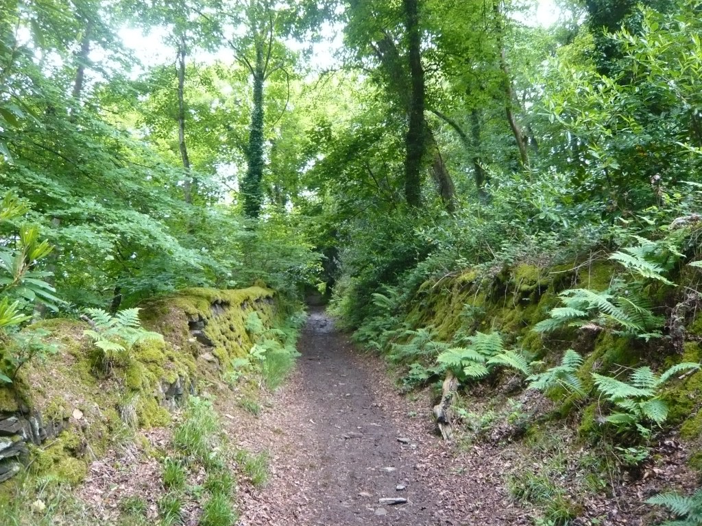
Picking up the coast path again, continue for a short way, then at a hairpin bend where the coast path doubles back on itself, continue ahead along a hollow way canopied by beech trees. Our route now has joined the Saints’ Way. Continue on this path to reach the lane. Turn left along the lane then right at the T-junction. On reaching the houses at Lankelly Lane, turn left then left again onto a footpath signposted the Saints’ Way. Note the lane here is called Prickly Post Lane!
Follow the path downhill to cross a small stream and go under a curious archway. Then up again. The woodland here has a very Rebecca-ish feel: cool, dark, lush and dripping with ferns and ivy. Looking at the map, I see it is all part of the Menabilly Wood.
Climb a stile and the scenery changes again to farmland. The path passes between a small cluster of buildings. Cross a drive and go over another stile. Continue ahead on a narrow path between fields. Descend steeply and cross a footbridge. Follow the path around into another field and another footbridge, then up to farm buildings. Enter the farmyard, turn right and follow the track up to the lane. Turn right along the lane.
Take the public footpath on your left and cross the field to rejoin the coast path, turning right to retrace your steps down through the woods to Polkerris, just in time for a pint at the Rashleigh Inn.
Verdict: A walk of contrasts indeed – dramatic coastline, shady woodland and idyllic-looking farmland. Plenty of interest irrespective of whether you are a fan of du Maurier and her works.

Leave a comment