An atmospheric walk across the Dartmoor of The Hound of the Baskervilles
I love Dartmoor. It’s not somewhere I have walked a lot, but I have always enjoyed the contrast of wild moorland that is everywhere dotted with remnants of human influence. Stone crosses, abandoned tin mines, beautifully constructed leats and ruins of ancient habitations – places once full of life and now lonely and abandoned. It conjures a special kind of thrill to walk there. Perhaps this is heightened by the fact I have only walked there in winter with mist, frost and early dark adding to the atmosphere.
It’s a perfect setting for the gothic intrigue and excitement of The Hound of the Baskervilles. I have to agree with the wicked Stapleton’s assessment of Dartmoor:
You never tire of the moor. You cannot think the wonderful secrets which it contains. It is so vast, and so barren, and so mysterious.
The Hound of the Baskervilles, Conan Doyle
A key part of the plot is Great Grimpen Mire. Devourer of ponies and foolish men alike, the bog is described as foul, rank, uncanny and makes ‘queer noises’. It is impassable, impersonal and a discreetly malevolent presence in the book. Foxtor Mires, the supposed inspiration for Great Grimpen Mire, seemed like just the place for a ramble.
Ramble #3
Map and route: OS Explorer map OL28. You can follow the route we took here.
Distance: 11.8 miles
Timing: About 6 hours, including stopping to eat, but equally not hanging around as the rain and dark closed in.
Start: Car park near Norsworthy Bridge on the edge of Burrator Reservoir, SX 568 693
Description:
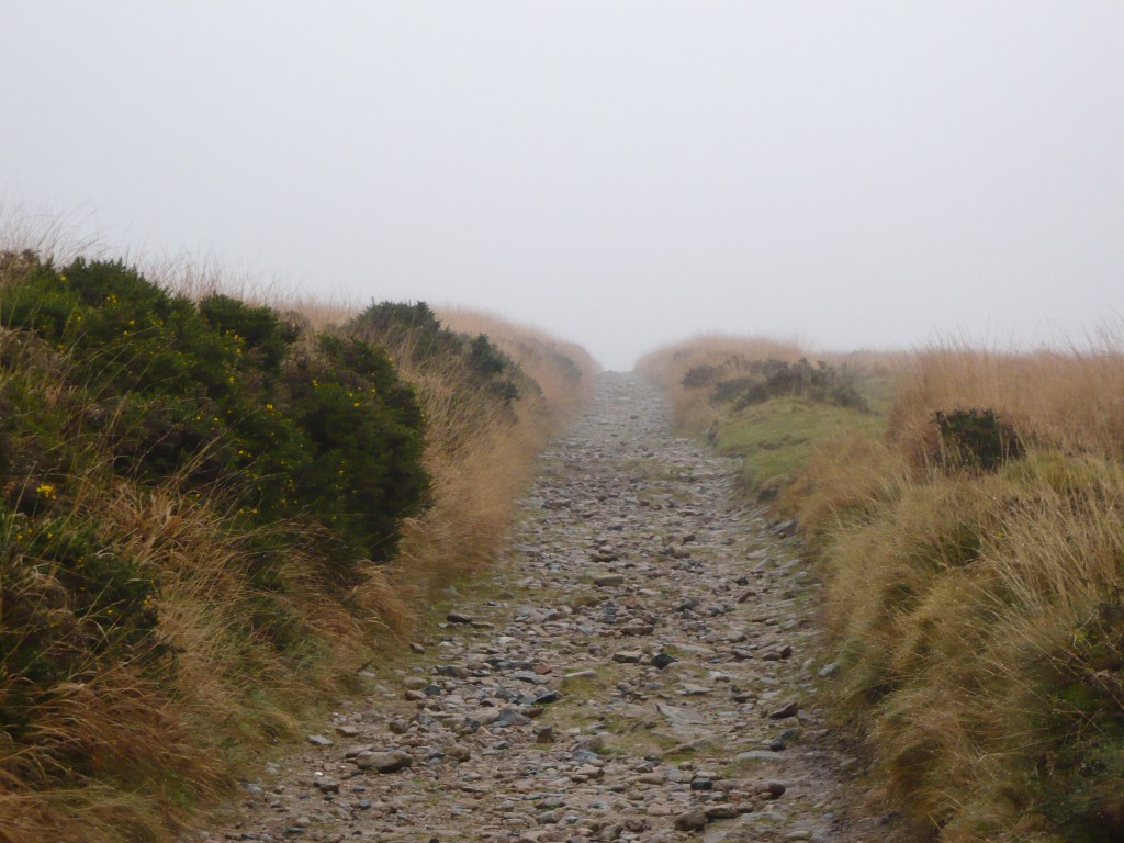
From the car park turn right on the road, then after crossing a stream, turn right along a stony track where the lane bends left over another bridge. Follow the track, turning right at an early T-junction and then again at another junction later on. The path steadily climbs with coniferous woodland to the left and open moorland and Down Tors off to the right.
When my companion and I walked this in November the weather was perfect – perfect for a route inspired by a gothic thriller that is. The tops of the trees were smeared by low cloud and the landscape appeared to shift under a veil of mist. Tors, ancient stones, cows and ponies suddenly loomed into view and then disappeared again.
The track continues as the woodland gives way to open moorland. Up to the left a stone cross comes into view. We took an informal path up to take a closer look at Crazywell Cross – named after the nearby supposedly bottomless pool (why are pools in lonely places so often ‘bottomless’?). This is just one of many stone crosses encountered on route, erected ostensibly to help guide travellers across the moor – www.dartmoor-crosses.org.uk is a treasure trove of information on Dartmoor crosses, compiled by a couple of walkers.

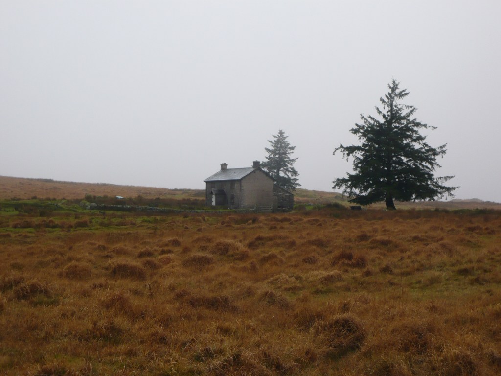
Re-joining the main track, another cross soon appears over to the right. The path is easy going and was flanked by tussocks of yellow and orangey grasses. This was the last point on the walk that we saw anyone until we arrived back at the car. Cross a couple of narrow streams and arrive at a slab stone crossing the neatly engineered leat at Olden Bridge. This is the Devonport Leat – built in the late 18th century to carry drinking water to docks at Plymouth. Here my companion and I decided to leave the main track, turning right to follow the leat. We started with the leat on our left, then crossed to the other bank at a footbridge. We passed an unmarked hut with a fluttering wind gauge and then another stone cross. The leat runs southwards, then bends to the east and disappears into a tunnel through the hillside near disused tin workings. Continue in the same direction uphill along a rough path. As we approached the height of the land, Nuns Cross appeared and shortly afterward the roof of Nun’s Cross Farm between two conifers. This remote building is suggested as the model for Merripit House in The Hound of the Baskervilles, perfectly situated as it is, overlooking Foxtor Mires.
Cross the track at the Nuns Cross and continue ahead with the farm on the right, then turn right to pick up a cart track. Follow this to cross the Devonport Leat again at a footbridge and then a stream at Nun’s Cross Ford. Follow the track as it climbs, becoming boggy in places. Yet another stone cross is visible over to the left. The track bends sharply right, but we turned left to follow the contour of the hillside. The rocky outcrop of Fox Tor itself can be seen ahead. The way briefly dips down to cross a stream, then continue up to the Tor.
At Fox Tor we sheltered behind the stones to drink coffee and eat sandwiches. The brown-green Foxtor Mires sit to the North East, at the bottom of the bowl created by the surrounding hills. It looked wide and featuresless, but no signs of struggling ponies or weird sucking sounds, other than from our own feet on the marshy ground.
From Fox Tor we headed south, picking our way across Fox Tor Girt to follow Black Lane (such as it is) for a short while before turning westwards towards the summit of Crane Hill. Here, things became distinctly confusing. I say ‘summit’ – Crane Hill is a flat-topped and featureless thing. We were now enveloped in cloud, so relying on visual clues was impossible. There was no clear path, only sheep tracks that appeared from nowhere then petered out or veered off in the wrong direction. It’s very easy to become disorientated in these conditions. And indeed, if you look at our tracked route, we walked for a while in a semi-circle before correcting. The ground was wet and lumpy with tussocks. The cheerful yellow grass of earlier in the day now just looked damp and jaundiced and I was sick of traipsing through it.
Referring regularly to a compass, we headed westwards over an unnamed hill and towards Eylesbarrow. Time was getting on and it was drizzling persistently, so when we hit a lovely wide, stony track we turned left onto it. I was greatly relieved at the opportunity for some easy walking for a while after the discombobulating stumble over featureless moorland. The track leads into the remains of Eylesbarrow Tin Mine, somewhere I might usually pause to explore, but it was raining hard now. Continue along the track as it descends, keeping right at a branch, to reach a small plantation of conifers at SX 581 674.
By now, the light was fading fast. Another leat crosses the path here. Using this as a helpful handrail, we turned right and followed its western bank. With more time and better light we might have taken a different route, maybe climbed Sheeps Tor. As it was, we followed the leat in the gloom until we bumped up against a high boundary wall. Thankfully the leat was easy to cross at this point and we headed northwards towards silhouetted trees, then turned left on a path alongside a wall. This brought us through a gate and back into the woodland surrounding Burrator Reservoir. Ignore the stiles off to the side that take you further into the woods. Continue straight ahead after climbing a stile at a gate. It was dark now and distinctly spooky. An owl screeched, the wind rustled the trees and something close by flapped nosily at our approach. Lichen on the tree trunks glowed in the moonlight. A wide puddle on the track in front of me, shiny and black, created the disconcerting illusion that I was about to step off an edge into an abyss. When the track reaches the lane, turn right and follow this back to the car park.
Verdict: A suitably atmospheric walk, especially given the conditions. If you prefer something less adventurous, go in fine weather with plenty of daylight. Either way, take a compass and map and/or GPS as navigation is challenging in places.

Leave a comment